

St. Eustatius, affectionately called Statia and also known as “the Historic Gem”, is just five miles long and two miles wide and is home to approximately 3,500 people. Statia is located in the northeastern Caribbean, 178 miles East of Puerto Rico and 35 miles South of St. Maarten. The capital and only city on the island is Oranjestad.
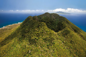
St. Eustatius consist of a presumably dormant volcano in the southeastern part of the island, called The Quill and an approximately 200,000 years old, extinct volcano in the northern part of the island, with in between a relatively flat terrain. St. Eustatius is an island with a land area of approximately 8.1 miles²/21 kilometers².
St. Eustatius, as part of the Leeward Islands, is characterized by its tropical climate with warm weather all year around. The mean annual temperatures range from 24° C (77° F) to 29° C (85° F). From July till November, St. Eustatius can be subject to hurricanes. There is a rainy season from October till January.
Statia was sighted in 1493 by Christopher Columbus. Throughout a swaggering colonial era that followed, the island had changed hands at least 22 times. In 1636, near the close of the 80 year war between Holland and Spain, the Dutch took possession. During the 17th and 18th century, Statia was a major trading centre with some 20,000 inhabitants and thousands of ships calling at her shores.
At this time it was known as the “Golden Rock” because of its immense wealth. A very large number of warehouses lined the road that runs along Oranje Bay; most (but not all) of these warehouses are now ruined and some of the ruins are partially underwater.
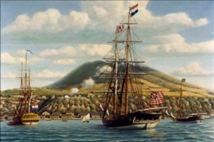 St. Eustatius also has a notable position in the history of the United States of America. On November 16, 1776 the island was the first foreign territory to officially salute, the Grand Union Flag of America. In response to this salute, the island’s recognition of America and the shipping of ammunition and gunpowder to America during the American Revolution, the English capture and destroy the island. The salute is commemorated every year on November 16th with many festivities and it is now known as Statia Day or Statia-America Day.
The official currency is the US dollar. Local banks will also exchange other foreign currency
St. Eustatius has always recognized its nature and marine life as one of its most valuable assets. The St. Eustatius National Parks Foundation, known locally as Stenapa is managing many ecotourism initiatives. Stenapa is a dedicated environmental organization developed to protect the marine and land environment as well as endangered species. They manage The Quill and Boven National Park, St. Eustatius National Marine Park and the Miriam C. Schmidt Botanical Garden.
The education system is European and more specifically, Dutch. But the general Instruction language is English. The range of educational facilities include primary, elementary, secondary and vocational:
The official language is Dutch, but English is the “language of everyday life” on the island and education is solely in English. A local English-based creole is also spoken informally. More than 52% of the population speak more than one language. The most widely spoken languages are English (92.7%), Dutch (36%), Spanish (33.8%) and Papiamento (20.8%).
Sint Eustatius is predominantly a Christian territory. The main denominations are Methodist 28.6%, Catholics 23.7%, Adventist 17.8%, Pentecostal 7.2% and Anglicans 2.6%.
The government is the largest employer on the island and the oil terminal owned by GTI is the largest private employer on the island.
The present port was built in 1993 and consists of an 80 meters long breakwater with a harbour-light and an 8 meters wide, 60 meters long pier with Ro-Ro accommodations of 15 meters wide. The harbor facility is located at Gallowsbay and has a storage capacity of 5.500 m2. . It is a so-called General Cargo Port Facility and one of the vital economic lifelines for the island. There is also an area where visiting pleasure crafts can moor and come on shore.
 Immigration and customs have an office at the harbour as well as the harbour master and staff who oversee loading and off-loading of containers and supplies from vessels. A daily image is the pilot ships maneuvering tankers and large vessels coming to St. Eustatius because of the oil terminal.
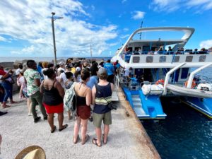
From St. Maarten and St. Kitts you can take a ferry to St. Eustatius with the Makana Ferry Service. M/V Makana is a semi-custom 72’ Sabre catamaran fast ferry that seats 149 passengers. You can choose to sit indoors or outdoors. Refreshment & WiFi available onboard.
F. D. Roosevelt Airport (IATA: EUX, ICAO: TNCE) is the airport located on the island of Sint Eustatius, Caribbean Netherlands. It was opened as “Golden Rock Airport” in 1946 and renamed for Franklin Delano Roosevelt. He had Dutch ancestors and in 1939 presented Sint Eustatius with a plaque in recognition of the “First Salute,” the first official salute of the flag of the newly declared independent United States in 1776. Members of the Roosevelt family lived on St. Eustatius in the 18th century and had possessions on the island.
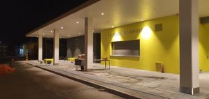 A development program to build a new Airport started in 2017. The previous airport was damaged due to hurricane Irma in 2017. Also due to the general average lifespan of an airport, it was necessary to construct a new building. The new airport terminal is operational since July 2021.
The only commercial airline currently flying to St Eustatius (20 minutes from St Maarten) is WINAIR.
Sint Eustatius became a member of the Netherlands Antilles when that grouping was created in 1954. Between 2000 and 2005 the member islands of the Netherlands Antilles voted on their future status. In a referendum on 8 April 2005, 77% of Sint Eustatius’ voters voted to remain within the Netherlands Antilles, compared to 21% who voted for closer ties with the Netherlands. After the other islands decided to leave, ending the Netherlands Antilles, the island council opted to become a special municipality of the Netherlands, like Saba and Bonaire. This process was completed in October 2010.
Both St Eustatius and Saba are now governed by an island authority and by Dutch central government. For many Dutch laws there is a special version for the Caribbean Netherlands. For example, social security is not on the same level as it is in the European Netherlands. Each island has an executive council that is responsible for that island’s day-to-day governance. The executive council implements the decisions of the island council. The executive council governs the island and is subject to scrutiny by the island council. See also www.statiagovernment.com.